
Alt text: Govindghat bridge on the route from Rishikesh to Hemkund Sahib, Uttarakhand
Rishikesh to Hemkund Sahib distance by road is 275 km — from Rishikesh to Govindghat, the last motorable point. From there, a 14-km trail leads to Ghangaria, followed by a 6-km climb to the Gurudwara at 4,329 metres above sea level. Total distance including the trek: approximately 295 km.
This isn't a route you drive to the doorstep. Between the mountain roads, the altitude, and the steep 6-km ascent from Ghangaria to Hemkund Sahib itself, most pilgrims and trekkers need 3 to 4 days minimum from Rishikesh — and that's if everything goes smoothly.
(Rishikesh → Govindghat)
(approx.)
(Govindghat → Shrine)
(Hemkund Sahib)
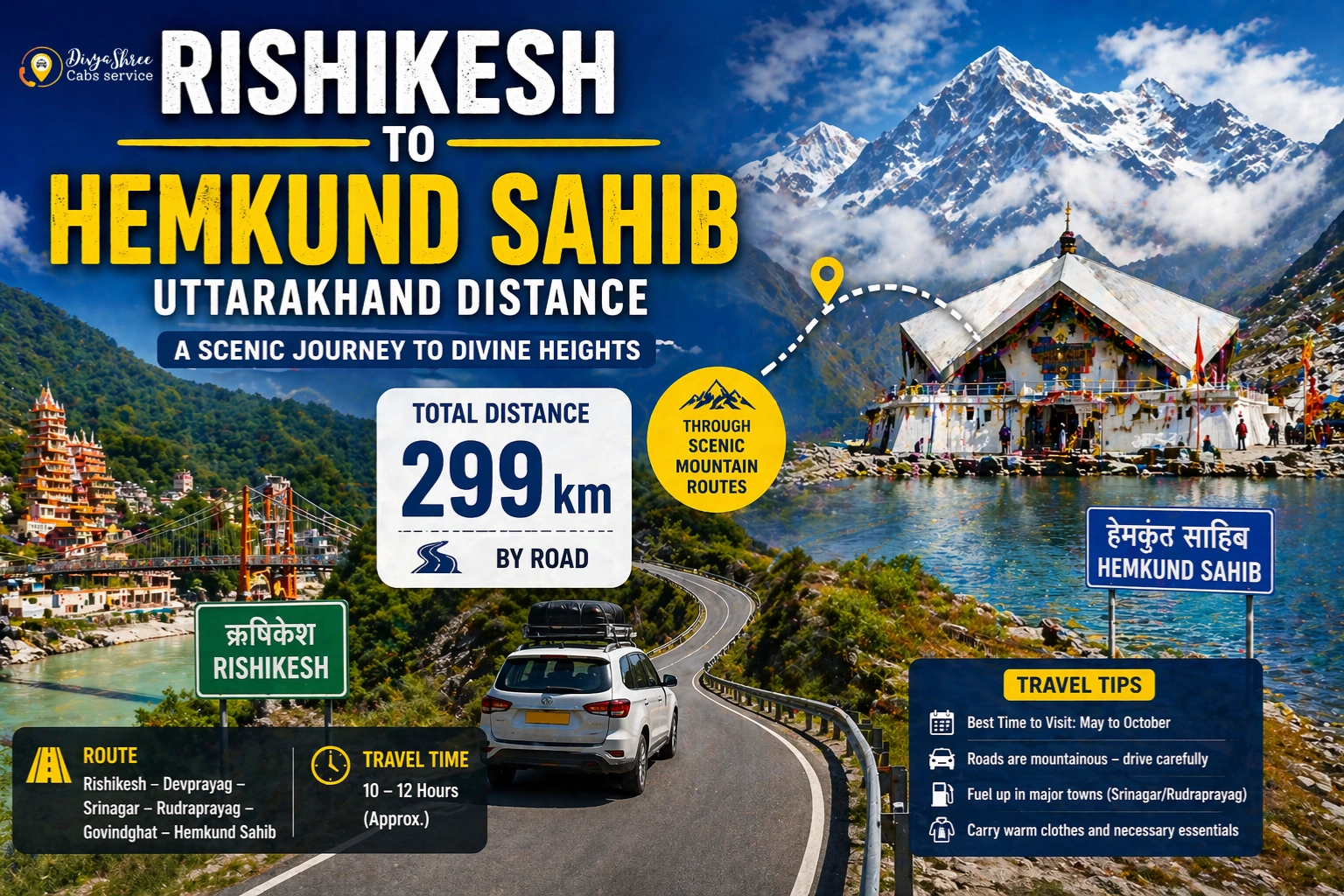
How Far Is Rishikesh to Hemkund Sahib by Road?
The road distance between Rishikesh and Hemkund Sahib — more precisely, Govindghat, the last motorable point — is 275 km. The drive takes roughly 8 to 9 hours depending on traffic, road conditions, and stops at the Panch Prayag confluences along the way.
From Govindghat, Ghangaria (also called Govinddham) is 14 km by trail or a short helicopter ride. Hemkund Sahib is another 6 km uphill from Ghangaria. So the full distance from Rishikesh to the Gurudwara gate — road plus trail — works out to around 295 km.
What Is the Road Route from Rishikesh to Govindghat?
The route follows National Highway 7 (Badrinath Highway) through the Alaknanda valley, passing through every major Prayag (river confluence) in Garhwal:
| Stop | Cumulative Distance | Notable Landmark |
|---|---|---|
| Rishikesh | 0 km | Starting point |
| Devprayag | 75 km | Ganga confluence (Bhagirathi + Alaknanda) |
| Rudraprayag | 143 km | Mandakini + Alaknanda merge |
| Karnaprayag | 178 km | Pindar + Alaknanda confluence |
| Nandprayag | 198 km | Nandakini + Alaknanda merge |
| Chamoli | 215 km | District HQ, fuel & rest stop |
| Joshimath | 250 km | 1,875 m altitude — recommended overnight halt |
| Govindghat ✅ | 275 km | Last motorable point — trek starts here |
| Ghangaria (on foot) | +14 km trail | Base camp at 3,050 m |
| Hemkund Sahib 🛕 | +6 km trail | Gurudwara at 4,329 m |
How Long Does the Drive from Rishikesh to Govindghat Take?
Under good conditions, plan for 8 to 9 hours of actual driving time. Add rest stops, meal breaks, and the reality of mountain roads — especially around Joshimath and Chamoli — and a full day is more realistic.
We recommend leaving Rishikesh no later than 5:00 AM if you want to reach Govindghat before dark. The roads between Chamoli and Joshimath can slow down significantly during peak yatra season (May–June and September–October), and driving these sections after sunset is best avoided.
Need a Taxi from Rishikesh to Govindghat?
We've been running Hemkund Sahib and Char Dham transfers since 2012. Direct pickup from Rishikesh, Haridwar, or Dehradun — Innova, Ertiga, or Tempo Traveller. No shared vehicles, no last-minute surprises.
Where Do You Stay Before the Trek?
Govindghat has basic guesthouses and dharamshalas and works as the arrival point. Most pilgrims, however, prefer to push on to Ghangaria (3,050 metres) the same evening and spend the night there — putting you 6 km from Hemkund Sahib the next morning.
Ghangaria has GMVN guesthouses, SGPC-run Sikh community dharamshalas, and private guest houses at varying price points. It's also the entry point for the Valley of Flowers National Park — one of the most worthwhile detours on this entire route if you can spare an extra day.
How Difficult Is the Trek to Hemkund Sahib?
The Govindghat to Ghangaria trail covers 14 km and gains 1,175 metres of altitude. Most fit adults cover it in 5 to 6 hours at a steady pace. Ponies and palanquins (dolis) are available at Govindghat for those who need them.
The Ghangaria to Hemkund Sahib stretch is the harder half — 6 km with a sharp gain to 4,329 metres. The last 2 km is particularly steep.
Is There a Helicopter Option to Hemkund Sahib?
Yes. Helicopter services operate between Govindghat and Ghangaria — not all the way to Hemkund Sahib. The flight takes about 8 to 10 minutes and costs approximately ₹3,500–₹4,500 per person one way. Bookings are made at the helipad near Govindghat and fill up fast during peak season.
This option is particularly popular with elderly pilgrims and families with young children since it eliminates the 14-km Govindghat–Ghangaria leg. The 6-km climb from Ghangaria to Hemkund Sahib still needs to be done on foot or by doli.
When Does Hemkund Sahib Open Each Year?
The Gurudwara is open from late May to mid-October each year. The exact date depends on snowmelt and is announced by the Shri Hemkund Sahib Trust — typically in the third or fourth week of May.
Booking a Taxi from Rishikesh to Govindghat
If you want a reliable taxi from Rishikesh or Haridwar to Govindghat — rather than navigating shared jeeps and state bus connections — we handle this route regularly. We've been running Char Dham and Himalayan yatra transfers since 2012 and know the road conditions, overnight stop options, and timing well.
Our drivers are hill-certified and familiar with every stretch from Rishikesh to Joshimath. We'll tell you which dhabas are safe to eat at near Chamoli, when to time the Joshimath bypass to avoid peak-hour traffic, and how early you need to leave to beat the Govindghat–Ghangaria morning rush.
Frequently Asked Questions
Let Us Handle the Road.
You Focus on the Pilgrimage.
Comfortable taxis from Rishikesh, Haridwar & Dehradun to Govindghat. Hill-certified drivers. We've been doing this route since 2012 — and we know every kilometre of it.
Reliable rides for a sacred journey — DivyaShree Cabs, Ukhimath, Uttarakhand (Since 2012)
Leave A Comment