
The Road-End Village Where the Kedarnath Trek Begins
At 1,982 metres, Gaurikund is where every vehicle stops and every pilgrim's feet begin. It sits 14 km below Kedarnath — the last point you can reach by road, and the first real step of the yatra on foot.
Gaurikund is the motorable road-end on the Kedarnath route. It sits in the Mandakini river valley at 1,982 metres, in the Rudraprayag district of Uttarakhand. Every pilgrim heading to Kedarnath — whether they plan to trek, ride a pony, take a doli, or fly by helicopter — passes through Gaurikund first.
The name comes from Goddess Gauri (Parvati), who is said to have meditated here before Lord Shiva accepted her as his consort. The Gauri Kund — a natural hot water pool fed by a thermal spring — sits right beside the Gaurikund temple. Pilgrims traditionally take a dip in this kund before starting the trek. The water stays warm year-round, which is worth knowing if you arrive at dawn when the mountain air is sharp.
From Gaurikund, the Kedarnath trek is 14 km one way. The trek passes through Jungle Chatti (4 km), Bheembali (8 km), and Lincholi (11 km) before reaching the temple. It is a steady uphill climb — not technically difficult, but it demands proper footwear, a light pack, and a sensible pace.
We have been driving pilgrims to Gaurikund since 2012. In our experience, the biggest mistake people make is underestimating how cold and muddy it can get here, even in May. Carry a rain cover and at least one warm layer regardless of what the weather apps say.
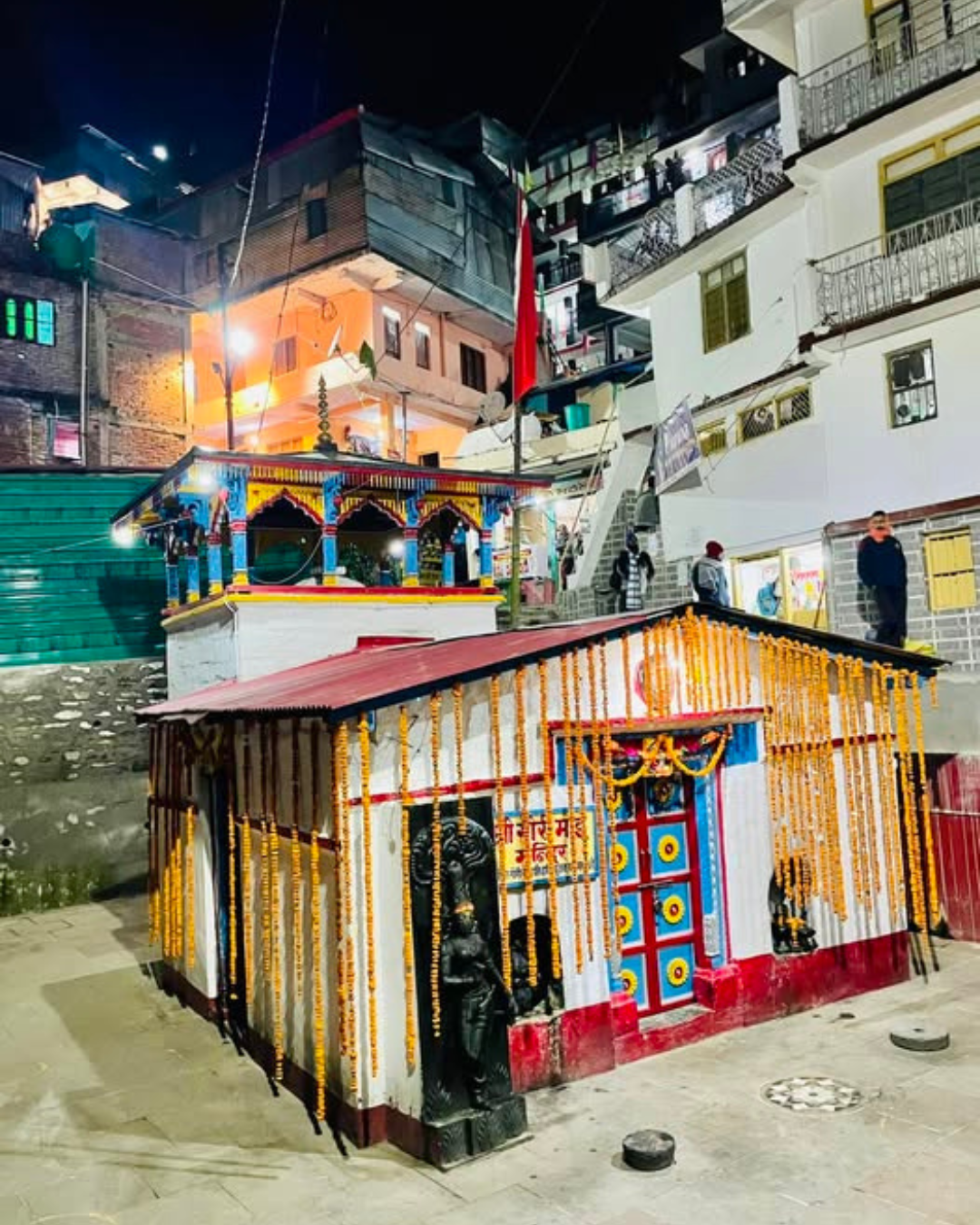
The Gaurikund temple is dedicated to Goddess Gauri. It stands just above the hot spring kund. Pilgrims offer prayers here before starting the trek — a practice followed for generations.
The hot kund is believed to have healing properties. Whatever you believe, a dip here at 5 AM before a 14 km climb wakes you up better than any coffee.
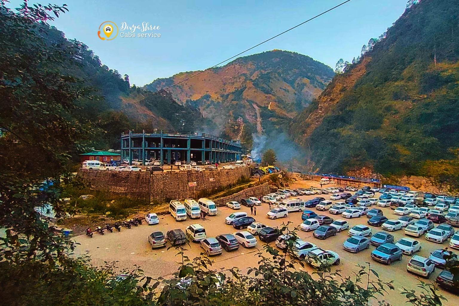
Gaurikund is only reachable via Sonprayag. Private vehicles are not allowed beyond Sonprayag during the yatra season — shared jeeps cover the last 5 km. Here are the exact distances you need to plan your trip:
Important: Private vehicles cannot go beyond Sonprayag during the yatra season. Your cab drops you at the Sonprayag parking lot, from where shared jeeps ply to Gaurikund at a government-fixed rate. We brief all passengers about this before departure so there are no surprises on arrival.
We drop you right at the Sonprayag checkpoint. Fixed price, no hidden charges, mountain-experienced driver.
Sonprayag is where the Mandakini and Sonprayag rivers meet and, more practically, where all private vehicles park during the Kedarnath Yatra season. The government enforces this cutoff strictly — no private taxi, car, or jeep from outside is permitted to go further.
From the Sonprayag checkpoint, government-authorised shared jeeps run continuously to Gaurikund. The 5 km ride takes about 15–20 minutes depending on traffic. The road is narrow and cuts along the river. On peak days like Akshaya Tritiya opening week, plan to reach Sonprayag by early morning rather than midday.
The government-fixed rate for Sonprayag to Gaurikund by shared jeep is nominal — expect ₹40–80 per person each way. Rates are displayed at the booking counter. Do not pay more than the listed price.
Shared jeeps operate from around 5 AM to 6 PM during peak season. Night movement is restricted. Pilgrims planning an early morning trek start should reach Sonprayag by 4 AM and wait for the first jeep.
Your Kedarnath Yatra registration is verified at Sonprayag before boarding the jeep. Carry the confirmation on your phone or as a printout. Without it, you cannot proceed further.
If you are carrying large bags, leave them at your Sonprayag lodge or the cloak room at the checkpoint. For the trek, carry only what you need for 1–2 days. Every extra kilo matters on a 14 km uphill.
 ️
️
The Gaurikund to Kedarnath distance is 14 km by the main trekking route. This is the classic pilgrim trail. There is also an alternate route via Lincholi ridge that adds about 2 km but is less crowded and more peaceful for those who want to walk quietly.
A fit adult walking at a steady pace covers the 14 km in 5 to 7 hours. First-timers, elderly pilgrims, and families with children typically take 7 to 9 hours. Start no later than 5 AM — arrive at Kedarnath by early afternoon, attend the afternoon aarti, and rest before early morning darshan next day.
The pony stand, mule loaders, and helicopter check-in counters are all here. Take the Gauri Kund dip, offer prayers at the temple, and start by 5–6 AM during the main season. The first 2 km are the steepest — slow and steady.
First proper rest stop with basic food stalls and medical aid. The trail passes through dense rhododendron and oak forest — quieter than sections closer to Gaurikund. Take a short break here if you started before sunrise.
The halfway mark. Tea stalls, hot food counters, and rest shelters. Altitude starts to be felt noticeably here. If you feel short of breath or a headache coming on, slow down and drink water. Do not push through altitude sickness.
The terrain opens above the treeline. The Kedarnath valley becomes visible for the first time — snow-covered peaks framing the valley ahead. This is where the weight of the journey quietly lands on most pilgrims.
The Kedarnath Jyotirlinga — one of the twelve most sacred Shiva shrines in India. The stone temple dates to the 8th century and stands facing the Mandakini glacier. Temple darshan timings: 6 AM–3 PM and 5 PM–9 PM. See our Kedarnath Travel Guide for complete darshan details.
Cab from Haridwar, Rishikesh, or Dehradun to Sonprayag — with a local driver who knows this route.
Gaurikund sits at nearly 2,000 metres. Even in May and June — the opening months of the yatra — temperatures at night drop to 5–8°C. Rain arrives without warning, especially in the afternoon. The weather here is mountain weather: it changes fast, and forecasts above 1,500 metres are only loosely reliable.
| Month | Day Temp (°C) | Night Temp (°C) | Conditions | Trek Status |
|---|---|---|---|---|
| May | 14–18°C | 4–8°C | Clear days, cold nights, some snowmelt on trail | Open |
| June | 15–20°C | 7–11°C | Good early June; monsoon arrives mid-June | Caution post-15th |
| July | 12–16°C | 6–10°C | Heavy rain, landslide risk on roads, trail slippery | Risky |
| August | 12–16°C | 5–9°C | Peak monsoon; frequent road closures near Rudraprayag | Risky |
| September | 13–18°C | 4–8°C | Monsoon recedes; roads clear; best month to go | Excellent |
| October | 8–13°C | 0–4°C | Clear skies; first snowfall possible above Lincholi | Open |
| November | 2–7°C | -3–1°C | Temple closes for winter; snow on upper trail possible | Closing Month |
| Dec – Apr | -5–5°C | -10–-2°C | Heavy snow; roads closed; Gaurikund inaccessible | Closed |
* Temperatures are approximate averages. Mountain weather varies significantly day to day. Always check NDMA and Uttarakhand government alerts before travel during July–August.
We are based in Ukhimath — 41 km from the Kedarnath shrine — and have been driving this route since 2012. When you book a cab with us to Sonprayag or Gaurikund, you are not getting a driver who looked up the route on Google Maps that morning. You are getting someone who has done this road hundreds of times, knows the seasonal landslide zones, and will tell you honestly if road conditions need an alternate plan.
Swift Dzire or similar
Up to 4 passengers
Comfortable for families
Up to 6 passengers
Most popular for yatra
Up to 6–7 passengers
Groups of 10–14
Best for large families
* Fares are approximate and vary by season and group size. All tolls and driver allowance are included. Contact us for an exact quote for your dates.
Fixed fares. No surge pricing. A driver who knows every bend on this road.
We have been sending pilgrims up to Gaurikund for over a decade. These are the things we actually tell our passengers before they leave — not generic advice you will find on every travel website.
The stretch from Tilwara to Sonprayag has single-lane sections and overhanging rock faces. Our drivers know every passing point. If you are self-driving, let uphill traffic pass first and go slow.
The trail goes from concrete steps to wet gravel to mud patches. Waterproof trekking shoes with ankle support are not optional — they are the single most important gear decision for this trek.
Starting by 4:30–5 AM avoids the 7–10 AM peak crowd on the trail. The path is lit in many sections; a headlamp handles the rest. You will reach Kedarnath comfortably in time for morning darshan.
At 8 km and 2,800 m, some pilgrims develop headaches or breathlessness. Slow down, drink water, and don't push through it. Diamox helps — take it the night before if you plan to use it.
BSNL is the most reliable network beyond Jungle Chatti. Other networks may work intermittently at Bheembali and then drop entirely. Download offline maps before leaving Gaurikund.
Hotels here fill up fast, especially during weekends and opening week. Book 2–3 weeks ahead for May and September. Prices range from ₹500 to ₹2,500 per night depending on the property and season.
We are on call or WhatsApp — no automated responses, no bots.
Most pilgrims visiting Gaurikund and Kedarnath are doing so as part of a wider Uttarakhand yatra. Here is what fits naturally around a Gaurikund visit:
Kedarnath is one of the four Char Dhams. Combining it with Yamunotri, Gangotri, and Badrinath in a 10–12 day circuit is the most complete pilgrimage in Uttarakhand. We provide full Char Dham taxi services for the entire route from one car throughout.
Five Shiva shrines — Kedarnath, Tungnath, Rudranath, Madhyamaheshwar, and Kalpeshwar. One of the most rewarding circuits in the Garhwal Himalaya. Takes 15–20 days and requires good fitness and prior trekking experience.
Located 60 km from Ukhimath via Dugalbitta, Chopta is the base for the Tungnath temple — the highest Shiva temple in the world at 3,680 m. The 3.5 km walk is manageable for moderate trekkers and the views are outstanding.
The Gaurikund to Badrinath distance is around 212 km via Rudraprayag and Chamoli. Most pilgrims cover this in 6–7 hours. Leave Sonprayag by early morning to arrive comfortably. See our Char Dham itinerary for the combined route plan.
Everything you need to know — distances, vehicles, weather, trek, and more.
We have been driving this route since 2012. Cab from Haridwar, Rishikesh, Dehradun, or Jolly Grant Airport — dropped at Sonprayag, fixed price, mountain-experienced driver who knows every km of the road.
Har Har Mahadev